
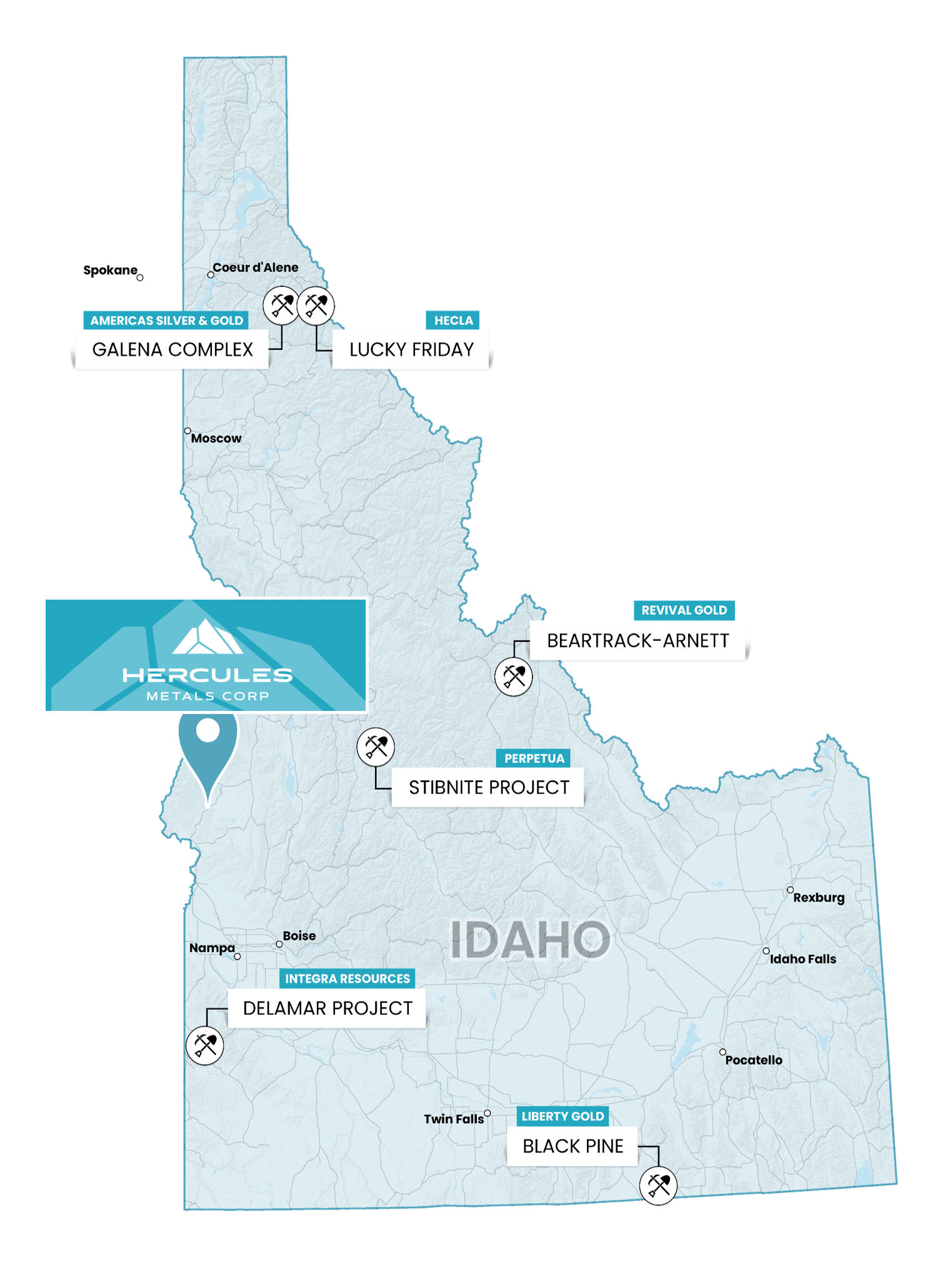
14 miles SW of the Hercules Project
The Mineral Project
Mineral Project
Overview
The Mineral Property was staked by renowned prospector, Merrill Palmer, who previously staked and discovered the Palmer VMS Project in Alaska.
The Mineral mining district was so-named after prospectors discovered rhyolite-hosted silver-copper-lead-zinc-bearing replacement mineralization in the area during the 1870s. A town site was established, and small-scale mining began in the 1880s and continued in earnest until the repeal of the Sherman Silver Purchase Act by U.S. President Cleveland in 1893, which caused a collapse in the silver price and decimated the silver mining industry. The mines and smelters at Mineral shut down at that time, and subsequent mining was very sporadic and conducted at a small scale through to 1950. The district has been essentially dormant ever since, apart from a few years of historical exploration during the late 1960s/early 1970s, but has never had a modern, systematic exploration approach applied to it.
Location
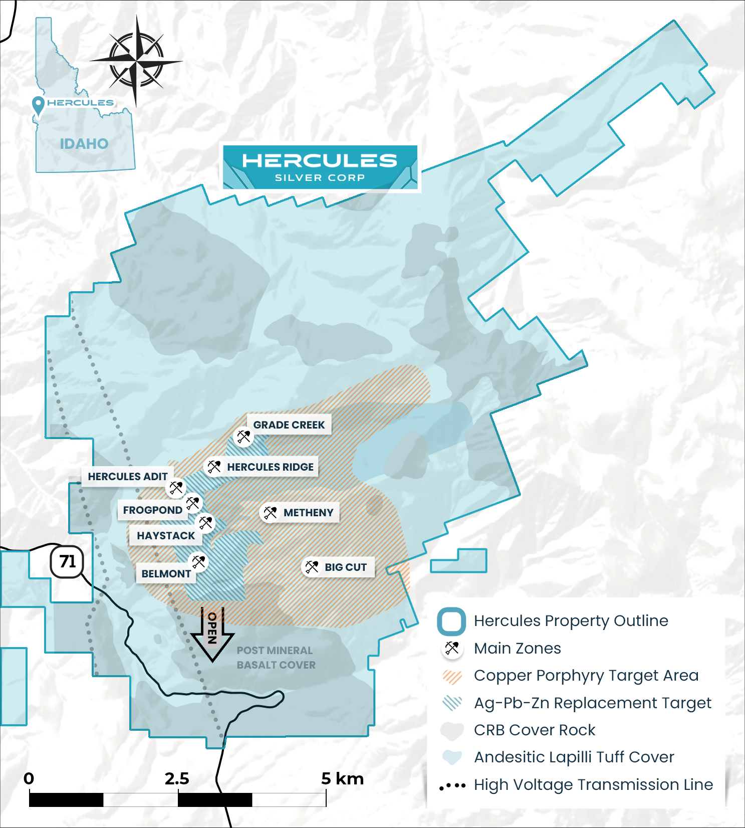
The property comprises of 2,843 acres with 87 unpatented lode mining claims within the Mineral mining district located on Bureau of Land Management administered lands, 14 miles southwest and along trend of the Company’s flagship Hercules Project in Washington County, Idaho.
Location
The property comprises of 87 unpatented lode mining claims within the Mineral mining district located on Bureau of Land Management administered lands, 14 miles southwest and along trend of the Company’s flagship Hercules Project in Washington County, Idaho.
Idaho was ranked 20th in the world for investment attractiveness, based on mineral endowments and public policy factors such as mining regulation, taxation and political support.
Fraser Institute’s Annual
Survey of Mining Companies,
2023
Last Mined
1882
Last Explored
1920
Acquired
1980
Highlights
Ownership
Hercules Silver has a lease agreement which grants the option to acquire a 100% interest in eighty-seven (87) unpatented mining claims.
Geology
Rhyolite-hosted silver (+/- lead-zinc) mineralization on the southern half of the Property and porphyry copper-gold style mineralization on the northern half of the Property. Porphyry mineralization hosted in a potassium rich diorite, which favors gold over molybdenum as an accessory metal.
Extensive Exploration History
Significant 1800s-era silver mining
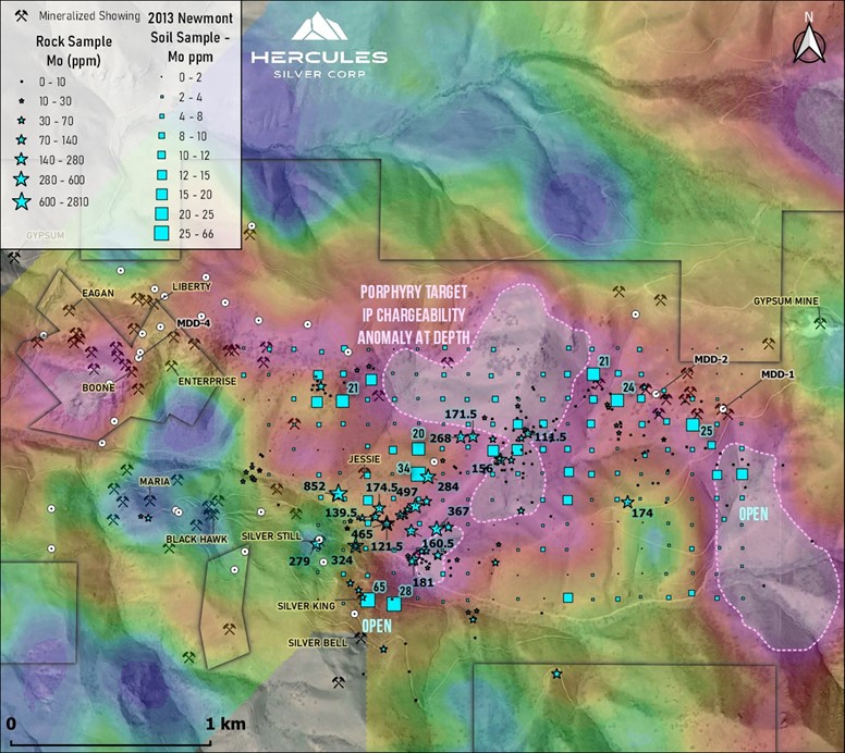
A single historical drill program was carried out by Cyprus Mines in 1969, of which only 2 holes targeted the porphyry. Drill hole MDD-2 intersected distal propylitic alteration grading 0.17% Cu over 266m, ending in mineralization at 271 m. Neither gold nor molybdenum was assayed for.
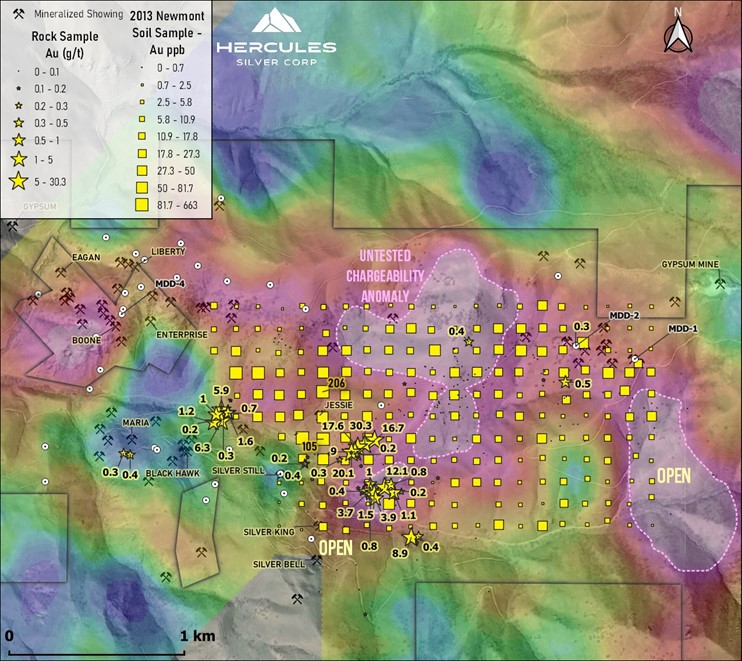
Newmont Corporation identified a 1.8 km long soil anomaly, with values ranging up to 6,370 ppm Cu, 206 ppb Au, and 65 ppm Mo.
Technical
Maps & Figures
Historical
Timeline
1870s
Prospectors discovered rhyolite-hosted silver-copper-lead-zinc-bearing replacement mineralization and small-scale mining commenced until the repeal of the Sherman Silver Purchase Act by U.S. President Cleveland in 1893.
1968
Cyprus Mines indicated the presence of two potential deposit types: rhyolite-hosted, replacement-style silver-copper-lead-zinc mineralization on the southern half of the Property (similar in nature to the near-surface mineralization style that occurs at Hercules) and porphyry copper-gold style mineralization, hosted in potassium-rich dioritic intrusive rocks which underlie the rhyolite and outcrop on the northern half of the Property.
1970
Cyprus carried out geological mapping, geochemical soil surveys, a 17 line-mile IP-resistivity geophysical survey, and a 40-hole program of reverse circulation, churn, and core drilling. Cyprus's soil survey outlined a >400 ppm Cu-in-soil anomaly over an approximate area of 1.5 km by 3 km, which overlies a broad zone of anomalous IP chargeability associated with the potassium-rich dioritic intrusions[1]. Cyprus drilled just two holes into the copper porphyry target zone. These holes were drilled prior to Cyprus conducting their IP survey.
2013
Newmont Corporation collected select rock grab samples and soil samples over a portion of the porphyry target. The soil results revealed a strong copper-gold-molybdenum anomaly, with values ranging up to 6,370 ppm Cu, 206 ppb Au, and 65 ppm Mo, over 1.8 kilometers in length[2]. The soil anomaly is consistent with a porphyry copper target that remains open for expansion.
2014
Radius Gold Inc. leased the Property from Merrill Palmer and flew a large airborne magnetic and radiometric survey, carried out selective rock and soil sampling and carried out a modern inversion of the digitized historical IP geophysical data. Geophysical inversions provide machine interpreted 3D models of both resistivity and chargeability data.
2023
Hercules entered into a lease option agreement between the Company, Anglo-Bomarc, U.S., Inc., a wholly owned subsidiary of the Company and Merrill Palmer which grants Hercules Silver the option to acquire a 100% interest in the Mineral property, comprising 87 unpatented lode mining claims.
Sources:
- Jones, K., and Worthington, J.E., 1970, The Mineral Project: Current Status and Potential. For Cyprus Mines Corporation.
- Reid, D., 2014. Mineral Mining District, Idaho. Presentation, March 2014.
Current
Exploration
The November 2022 Phase I drill program was designed to test and verify historical drilling assays as well as gain the geological and geotechnical information needed to support a Phase II drilling campaign in early spring of 2023.
The program consisted of infill and step-out holes at the Frogpond and Hercules Adit Zones with additional step-out holes to test open zones with little to no prior drilling.
A total of 1,995 feet in 9 drill holes was completed, with several holes bottoming in mineralization, and high-priority areas were tested within the Frogpond and Hercules Adit Zones for potential inclusion in future resource estimates. (See Feb 28 NR).
Highlights of the program include:
- Strong grade over multiple significant intervals, including drill hole HER-22-01, the first hole of the program, which intercepted 38 meters of 353 g/t Ag, 0.64% Pb, 2.28% Zn and 0.16% Cu (487 g/t AgEq), beginning at a shallow depth of 26 m depth in first drill hole, HER-22-01.
- HER-22-01 included a higher-grade intercept of 4.57 m grading 791 g/t Ag, 1.25% Pb, 4.06% Zn and 0.18% Cu (1,021 g/t AgEq) starting at 29 m.
- HER-22-07 intersected 44.2 m grading 224 g/t Ag, 0.32% Pb, 0.38% Zn and 0.09% Cu (258 g/t AgEq) starting at 1.5 m.
- Drilling grades significantly exceed grades sampled at surface, supporting the concept of potential supergene enrichment of mineralization below surface.
- Confirmed the presence of a high-grade shoot (the P-19 Shoot) at the east end of the Frogpond Zone; open at depth to the east.
- Confirmed the presence of shallow, high-grade mineralization at Frogpond and Hercules Adit Zones, with additional follow-up planned for Phase II.
The 2022 3D IP survey over the Hercules Adit, Frogpond and Belmont Zones, identified a large untested chargeability anomaly at depth. The results demonstrated the excellent exploration potential at Hercules and contributed to 2023 drilling.
- Strong chargeability values (>25ms), below historical drilling, and over a continuous strike length of 1.8 kilometers
- Anomaly is coincident with the untested base of the Hercules Rhyolite where surface mapping indicates the strongest silver mineralization to occur (See Oct 18 NR)
- Lower portion of anomaly lies down dip of the copper mineralization hosted within the underlying Seven Devils volcanics
- Anomaly remains open up-dip to the southeast
The summer 2023 Phase II drill program consisted of step-out holes designed to test for extensions of historical mineralization, verify previous historical drilling and test a series of new targets generated by greenfields exploration.
The 6,000 m program focused on the following targets:
- Hercules Adit and Frogpond Zones: Step-out holes aiming to extend mineralization, as well as infill and further verify historical drilling results.
- Hercules Rhyolite: Robust silver targets identified through surface mapping, geophysics and geochemistry, including at the Hinge, Haystack and Belmont Zones.
- New porphyry copper-silver (+/- gold) target: Interpreted as the center of a large zoned system and feeder for the surrounding silver (+/-lead-zinc) hosted in the Hercules Rhyolite.
- Large-scale untested chargeability anomaly at depth, potentially representing a large body of strong sulfide mineralization.
Five deep drill holes encountered strong phyllic alteration, which is typical of the margins of a porphyry system, over approximately 450m x 500m, called the Leviathan Porphyry. HER-23-05, the first hole to test a large-scale (>1.8km) blind chargeability anomaly, intersected 185.29m of 0.84% Cu and 111 ppm Mo from 246m to 431.2m, including 45.33m of 1.94% Cu.
Additional step-out holes drilled at various orientations to the southeast of HER-23-05, where chargeability data was currently available, intersected similar alteration, veining and copper mineralization over variable lengths. Many directions remain to be tested, and the potassic center, which often carries the highest grades within porphyry systems, remains to be found.
The 2023 property-wide deep-seeking IP survey was designed to explore the new Leviathan Porphyry at depth. The new survey expanded on the initial chargeability anomaly first tested last year and revealed trends that are comparable with known porphyry copper systems.
The deep-seeking 3D IP, direct current resistivity and drone magnetic geophysics over the area to be drill tested in 2024, revealed multiple prospective targets, coincident with the direction of increasing copper porphyry grades seen in the initial 2023 deep discovery holes drilled at the Leviathan Porphyry.
- Conductivity anomaly below historical mining at the Belmont Zone
- Kilometers of prospective chargeability from Belmont to Grade Creek
- Moderate chargeability anomaly near surface at the Big Cut Skarn provides an additional satellite drill target
- 3D magnetic inversion reveals magnetic highs potentially associated with a potassic core.
- Soil sampling, mapping, and prospecting planned to cover extensions of newly identified geophysical targets
The summer 2024 Phase III program encompasses 20,000m of drilling which will consist of drilling 200m centers along NW-SE fences, starting west of the 2023 discovery area, and testing new magnetic anomalies and conductivity and chargeability anomalies identified by the 2023 deep-seeking 3D IP survey.
- The phase III drill program will focus on multiple targets, including:
- Drilling on 200m centers along NW-SE fences, starting with three holes to the west, northwest and north from HER-23-05, which had the best copper intercept in 2023 of 185.29m of 0.84% Cu and 111 ppm Mo from 246m to 431.2m, including 45.33m of 1.94% Cu in an upper enrichment blanket.
- A conductivity anomaly at the Belmont Zone identified by the 2023 IP survey. Prospecting of historical waste dumps at Belmont recently uncovered strong chalcocite mineralization, potentially sourced from an underlying enrichment blanket.
- Two magnetic high anomalies below the Belmont and Grade Creek Zones, potentially representative of magnetite alteration, commonly associated with a central potassic zone.
- Near surface chargeability anomaly at the Big Cut Skarn, situated at the edge of the IP survey.
Historical
Drilling
Paper drill logs from the 1960’s-1980’s were recovered and digitized into a modern database. Assays include:
Hole ID | Year | From (m) | To (m) | Interval (m) | Ag (g/t) | Pb (%) | Zn (%) |
| 80-1 | 1980 | 73.15 | 103.63 | 30.48 | 335.6 | 0.17 | 0.54 |
| including | 1980 | 82.3 | 91.44 | 9.14 | 828.2 | 0.24 | 0.8 |
| including | 1980 | 96.01 | 99.06 | 3.05 | 317.8 | 0.04 | 0.22 |
| 80-12 | 1980 | 7.62 | 22.86 | 15.24 | 56 | No Assay | No Assay |
| AND | 1980 | 36.58 | 74.68 | 38.1 | 144.3 | 0.13 | 0.37 |
| including | 1980 | 50.29 | 53.34 | 3.05 | 485 | No Assay | No Assay |
| AND | 1980 | 82.3 | 97.54 | 15.24 | 129 | 0.02 | 0.07 |
| 80-13 | 1980 | 114.3 | 141.73 | 27.43 | 394.3 | 0.21 | 0.7 |
| including | 1980 | 115.82 | 126.49 | 10.67 | 904.3 | 0.32 | 1.31 |
| 80-04 | 1980 | 85.34 | 108.2 | 22.86 | 297.4 | 0.22 | 0.26 |
| 83-42 | 1983 | 1.52 | 45.72 | 44.2 | 143.9 | 0.13 | 0.26 |
| including | 1983 | 12.19 | 15.24 | 3.05 | 807.7 | 0.25 | 0.21 |
| 83-P19 | 1983 | 15.24 | 62.48 | 47.24 | 377.5 | 0.39 | 0.91 |
| Including | 1983 | 24.38 | 32 | 7.62 | 606.2 | 0.49 | 1.64 |
| Including | 1983 | 35.05 | 44.2 | 9.15 | 1,166.40 | 1.05 | 1.82 |
| 83-P7 | 1983 | 42.67 | 74.68 | 32.01 | 174.6 | 0.56 | 2.21 |
| 84-P3 | 1984 | 25.91 | 71.63 | 45.72 | 380.3 | 0.61 | 3 |
| Including | 1984 | 27.43 | 33.53 | 6.1 | 998.9 | 1.18 | 7.53 |
| 84-P6 | 1984 | 4.57 | 44.2 | 39.63 | 175.9 | 0.12 | 0.32 |
| AC 7710 | 1977 | 44.2 | 59.44 | 15.24 | 770 | 1.36 | 0.2 |
| Including | 1977 | 48.77 | 56.39 | 7.62 | 1,377.70 | 2.62 | 0.3 |
| AND | 1977 | 126.49 | 132.59 | 6.1 | 146.2 | 0.05 | 0.1 |
| DDH-3 | 1965 | 33.53 | 35.05 | 1.52 | 289.3 | 0.1 | No Assay |
| AND | 1965 | 44.2 | 68.58 | 24.38 | 122.9 | No Assay | No Assay |
| AND | 1965 | 82.3 | 117.35 | 35.05 | 266.7 | 0.69 | 3.63 |
| Including | 1965 | 92.96 | 99.06 | 6.1 | 718.5 | 0.48 | 1.63 |
| RC 771 | 1977 | 77.72 | 109.73 | 32.01 | 300.3 | 0.22 | 0.49 |
| including | 1977 | 97.54 | 106.68 | 9.14 | 750.1 | 0.34 | 0.4 |
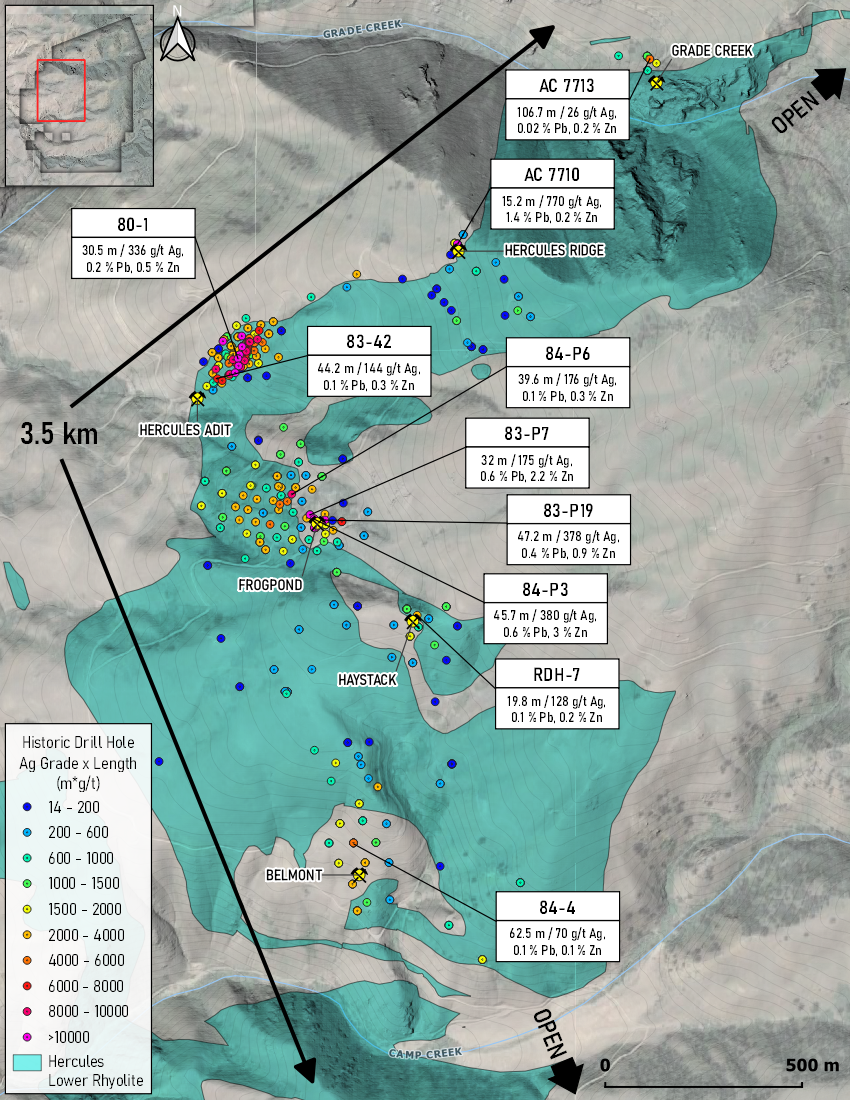
Above: Select historical intercepts from 1965-1988 demonstrate some of the better holes drilled